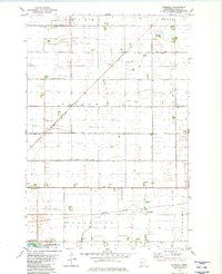
1981 Map of Everdell
USGS Topo · Published 1981About this map
Everdell sits at the heart of this agricultural landscape in Wilkin County, where the iron rails of the Burlington Northern cut a diagonal path through the prairie. The map reveals a highly engineered hydraulic system essential to Red River Valley farming, characterized by an extensive network of man-made waterways including County Ditch No 3, County Ditch No 31, and County Ditch No 37. These channels reflect the transition of the marshy plains into productive cropland during the late 20th century.
Find a feature on this map
20 named features on this map. Tap any name to fly to it.
Don’t see what you’re looking for? This feature index may not catch every label — zoom into the map to look around manually.
Map Details
Editions of this 1981 Everdell Map
This is the sole edition of this map. No revisions or reprints were ever made.
Other maps of this area

1904 · Wahpeton
USGS Topo · 1:125,000

1919 · Rothsay
USGS Topo · 1:62,500

1951 · Rothsay
USGS Topo · 1:62,500

1951 · Campbell
USGS Topo · 1:62,500

1953 · Fargo
USGS Topo · 1:250,000

1956 · Fargo
USGS Topo · 1:250,000

1964 · Wahpeton
USGS Topo · 1:24,000
1973 · South of Wahpeton
USGS Topo · 1:24,000
1973 · Wahpeton NE
USGS Topo · 1:24,000
1981 · Rothsay NW
USGS Topo · 1:24,000