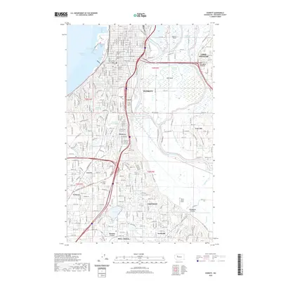
2020 Map of Everett
USGS Topo · Published 2020About this map
Everett and its surrounding communities are defined by a complex network of river channels and modern infrastructure. This 2020 map details the industrial and residential landscape where the Snohomish River meets Possession Sound and Port Gardner. The drainage basin is marked by intricate waterways including Steamboat Slough, Deadwater Slough, and Ebey Slough, which wrap around Ebey Island and Spencer Island. This era of the city's development is characterized by high-density transit corridors like Interstate 5 and the BNSF Railway that bisect neighborhoods such as Lowell and Pinehurst. Educational and civic centers, including the Snohomish County Courthouse and Trinity Lutheran College, anchor the urban core, while suburban growth extends southward toward Mill Creek and Silver Lake, illustrating the post-war expansion of the Puget Sound region.
Find a feature on this map
63 named features on this map. Tap any name to fly to it.
Don’t see what you’re looking for? This feature index may not catch every label — zoom into the map to look around manually.
Map Details
Editions of this 2020 Everett Map
This is the sole edition of this map. No revisions or reprints were ever made.
Other maps of this area

1895 · Snohomish
USGS Topo · 1:125,000

1897 · Seattle
USGS Topo · 1:125,000

1911 · Mount Vernon
USGS Topo · 1:125,000

1941 · Marysville
USGS Topo · 1:62,500

1942 · Edmonds
USGS Topo · 1:62,500

1943 · Marysville
USGS Topo · 1:62,500

1943 · Stanwood
USGS Topo · 1:62,500

1944 · Everett
USGS Topo · 1:62,500
1953 · Bothell
USGS Topo · 1:24,000
1953 · Maltby
USGS Topo · 1:24,000