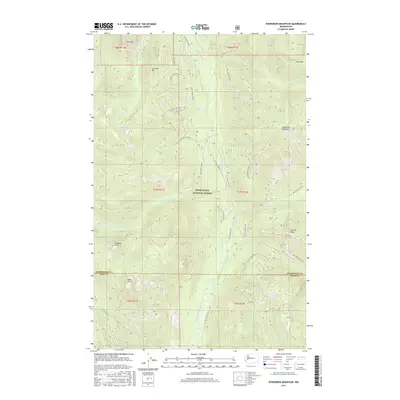
2017 Map of Evergreen Mountain
USGS Topo · Published 2017About this map
Snoqualmie National Forest dominates this mountain landscape where the Beckler River and its tributaries carve deep drainages through the Cascade Range. The map illustrates a complex network of forest development roads, including Nat For Dev Rd 65, which provide access to high-elevation landmarks like Evergreen Mountain and the secluded Boulder Lake. The topography is defined by prominent summits such as San Juan Hill, Silica Mtn, and Bear Mtn. Along the southern boundary, the transition from Snohomish County to King County is marked near Eagle Rock. This survey documents the modern infrastructure supporting timber management and backcountry recreation, tracing the paths of the Rapid River and numerous mountain creeks including Fourth-of-July Cr and Johnson Cr.
Find a feature on this map
43 named features on this map. Tap any name to fly to it.
Don’t see what you’re looking for? This feature index may not catch every label — zoom into the map to look around manually.
Map Details
Editions of this 2017 Evergreen Mountain Map
This is the sole edition of this map. No revisions or reprints were ever made.
Other maps of this area

1902 · Skykomish
USGS Topo · 1:125,000

1905 · Skykomish
USGS Topo · 1:125,000

1957 · Wenatchee
USGS Topo · 1:250,000

1965 · Captain Point
USGS Topo · 1:24,000

1965 · Evergreen Mtn
USGS Topo · 1:24,000

1965 · Grotto
USGS Topo · 1:24,000

1965 · Monte Cristo
USGS Topo · 1:24,000

1965 · Skykomish
USGS Topo · 1:24,000
1965 · Bench Mark Mtn
USGS Topo · 1:24,000
1965 · Baring
USGS Topo · 1:24,000