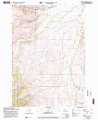
1997 Map of Everson Creek
USGS Topo · Published 2002About this map
Brenner Ranch and Donovan Ranch anchor this high-altitude landscape in the Beaverhead National Forest, where late-twentieth-century ranching operations persisted alongside legacy mining activity. The map traces the winding Lewis and Clark National Historic Trail as it traverses the drainages of Bloody Dick Creek and Horse Prairie Creek. This area is defined by its complex water management and resource extraction, illustrated by the Upper Bloody Dick Ditch and numerous prospects and tailings scattered near the South Fork and Jeff Davis Creek.
Find a feature on this map
27 named features on this map. Tap any name to fly to it.
Don’t see what you’re looking for? This feature index may not catch every label — zoom into the map to look around manually.
Map Details
Editions of this 1997 Everson Creek Map
This is the sole edition of this map. No revisions or reprints were ever made.
Other maps of this area

1955 · Dubois
USGS Topo · 1:250,000

1955 · Dillon
USGS Topo · 1:250,000

1957 · Dillon
USGS Topo · 1:250,000

1958 · Dubois
USGS Topo · 1:250,000

1958 · Dillon
USGS Topo · 1:250,000

1959 · Grant
USGS Topo · 1:62,500

1962 · Dillon
USGS Topo · 1:250,000

1965 · Dillon
USGS Topo · 1:250,000

1965 · Deadman Pass
USGS Topo · 1:24,000

1965 · Jeff Davis Peak
USGS Topo · 1:24,000