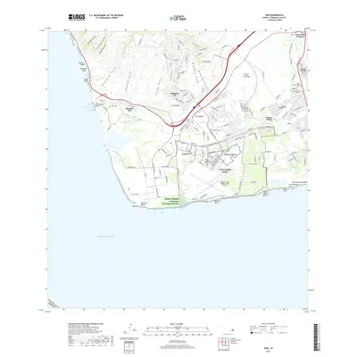
2017 Map of Ewa
USGS Topo · Published 2017About this map
The coastal shelf of south-central O‘ahu is defined by a dense mix of residential growth and extensive military history. Kalaeloa occupies the prominent southern peninsula, featuring the Kalaeloa (John Rodgers Field) Airport and military installations like CSO Barbers Point and NG Kalaeloa. To the north, the foothills of the Waianae Range are carved by several deep gulches, including Waimanalo Gulch and Makakilo Gulch, which provide a dramatic backdrop to the hilltop communities of Makakilo City and Pu‘umakakilo.
Find a feature on this map
134 named features on this map. Tap any name to fly to it.
Don’t see what you’re looking for? This feature index may not catch every label — zoom into the map to look around manually.
Map Details
Editions of this 2017 Ewa Map
This is the sole edition of this map. No revisions or reprints were ever made.
Other maps of this area

1953 · Schofield Barracks
USGS Topo · 1:24,000

1953 · Ewa
USGS Topo · 1:24,000

1953 · Puuloa
USGS Topo · 1:24,000

1954 · Oahu
USGS Topo · 1:250,000

1954 · Waianae
USGS Topo · 1:24,000

1954 · Waipahu
USGS Topo · 1:24,000

1959 · Waipahu
USGS Topo · 1:24,000
1959 · Puuloa
USGS Topo · 1:24,000

1960 · Schofield Barracks
USGS Topo · 1:24,000

1961 · Oahu
USGS Topo · 1:250,000