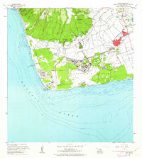
1962 Map of Ewa
USGS Topo · Published 1963About this map
Sugar cane cultivation and industrial expansion define this coastal landscape of Oahu in the early 1960s. The town of Ewa serves as a central hub, surrounded by a cluster of plantation-era worker communities including Renton Village, Fernandez Village, and Tenney Village. The prominent Sugar Mill and its associated infrastructure reflect the agricultural roots of the Ewa Plain, while a large Oil Refinery and Cement Plant near the coast signal the mid-century shift toward heavy industry.
Find a feature on this map
68 named features on this map. Tap any name to fly to it.
Don’t see what you’re looking for? This feature index may not catch every label — zoom into the map to look around manually.
Map Details
Editions of this 1962 Ewa Map
2 editions found
Other maps of this area

1953 · Schofield Barracks
USGS Topo · 1:24,000

1953 · Ewa
USGS Topo · 1:24,000

1953 · Puuloa
USGS Topo · 1:24,000

1954 · Oahu
USGS Topo · 1:250,000

1954 · Waianae
USGS Topo · 1:24,000

1954 · Waipahu
USGS Topo · 1:24,000

1959 · Waipahu
USGS Topo · 1:24,000
1959 · Puuloa
USGS Topo · 1:24,000

1960 · Schofield Barracks
USGS Topo · 1:24,000

1961 · Oahu
USGS Topo · 1:250,000