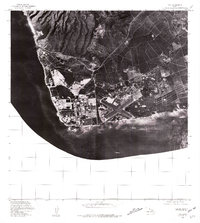
1977 Map of Ewa
USGS Topo · Published 1981About this map
Barbers Point anchors the southwest corner of Oahu in this detailed orthophotoquad, where the industrial and military footprint of the late 1970s is etched into the coastal landscape. Aerial photography from late 1976 and early 1977 reveals the geometric patterns of the Naval Air Station runway system and the sprawling storage tanks of the nearby refinery complex. The contrast between the developed flats and the darker, shadowed slopes rising toward the north is sharp, showing the division between the intense activity at the shoreline and the upland terrain. Further up the coast, Kahe Point stands as a distinct landmark overlooking the Pacific Ocean. This image-based survey provides an exacting look at the infrastructure that defined the Ewa plain during a period of significant logistical and energy-sector growth in the islands.
Find a feature on this map
3 named features on this map. Tap any name to fly to it.
Don’t see what you’re looking for? This feature index may not catch every label — zoom into the map to look around manually.
Map Details
Editions of this 1977 Ewa Map
This is the sole edition of this map. No revisions or reprints were ever made.
Other maps of this area

1953 · Schofield Barracks
USGS Topo · 1:24,000

1953 · Ewa
USGS Topo · 1:24,000

1953 · Puuloa
USGS Topo · 1:24,000

1954 · Oahu
USGS Topo · 1:250,000

1954 · Waianae
USGS Topo · 1:24,000

1954 · Waipahu
USGS Topo · 1:24,000

1959 · Waipahu
USGS Topo · 1:24,000
1959 · Puuloa
USGS Topo · 1:24,000

1960 · Schofield Barracks
USGS Topo · 1:24,000

1961 · Oahu
USGS Topo · 1:250,000