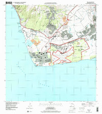
1998 Map of Ewa
USGS Topo · Published 2000About this map
The coastal plain of Southwest Oahu underwent significant transition by the late 1990s, anchored by the expansive Naval Air Station (Closed) Barbers Point and the Kalaeloa Airport John Rodgers Field. The landscape is a mix of residential clusters like Makakilo City perched on the southern slopes of the Waianae Range and industrial features such as the Coral Pit and Barbers Point Harbor.
Find a feature on this map
66 named features on this map. Tap any name to fly to it.
Don’t see what you’re looking for? This feature index may not catch every label — zoom into the map to look around manually.
Map Details
Editions of this 1998 Ewa Map
This is the sole edition of this map. No revisions or reprints were ever made.
Other maps of this area

1953 · Schofield Barracks
USGS Topo · 1:24,000

1953 · Ewa
USGS Topo · 1:24,000

1953 · Puuloa
USGS Topo · 1:24,000

1954 · Oahu
USGS Topo · 1:250,000

1954 · Waianae
USGS Topo · 1:24,000

1954 · Waipahu
USGS Topo · 1:24,000

1959 · Waipahu
USGS Topo · 1:24,000
1959 · Puuloa
USGS Topo · 1:24,000

1960 · Schofield Barracks
USGS Topo · 1:24,000

1961 · Oahu
USGS Topo · 1:250,000