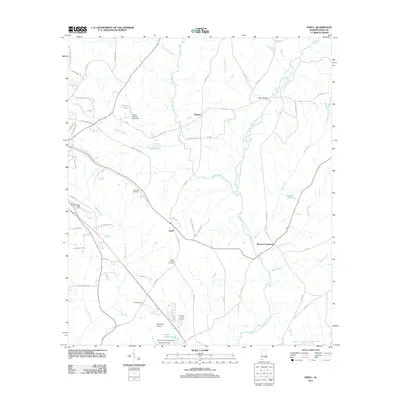
2011 Map of Ewell
USGS Topo · Published 2011About this map
The West Fork Choctawhatchee River and its numerous tributaries, including Judy Creek and Middle Creek, define the rural geography of Dale County in this 2011 survey. Small communities like Mabson, Ewell, and Browns Crossroad are connected by a network of county roads, showing the persistent residential patterns of the Alabama wiregrass region. Genealogy researchers will find several family-named burial grounds across the landscape, including the Mims Family Cemetery, Lee Cemetery, and Newman Family Cemetery. The presence of Blackwell Field and Hunt AHP Airport indicates the area's continued importance for local and military aviation. Hydrology is central to the area's layout, with several small reservoirs like James Crooks Lake and Johnsons Pond created by landmarks such as the Carver Johnson Lake Dam.
Find a feature on this map
67 named features on this map. Tap any name to fly to it.
Don’t see what you’re looking for? This feature index may not catch every label — zoom into the map to look around manually.
Map Details
Editions of this 2011 Ewell Map
This is the sole edition of this map. No revisions or reprints were ever made.
Other maps of this area

1942 · Enterprise
USGS Topo · 1:125,000

1948 · Ozark
USGS Topo · 1:62,500

1950 · Ozark
USGS Topo · 1:62,500

1953 · Dothan
USGS Topo · 1:250,000

1954 · Dothan
USGS Topo · 1:250,000

1955 · Dothan
USGS Topo · 1:250,000

1960 · Ewell
USGS Topo · 1:24,000

1960 · Pinckard
USGS Topo · 1:24,000
1960 · Daleville
USGS Topo · 1:24,000
1960 · Ozark
USGS Topo · 1:24,000