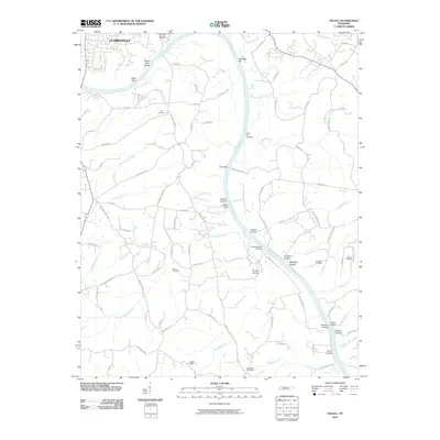
2010 Map of Excell
USGS Topo · Published 2010About this map
The Cumberland River carves a deep path through this landscape south of Clarksville, revealing a river-oriented geography defined by historic landings and navigation hazards. Landings such as Lime Kiln Landing, Wilsons Landing, and Sheltons Landing suggest the enduring importance of the waterway for commerce and local transit. The topography is marked by named bars and islands, including Seven Mile Island and the curiously named Whiskey Bar, while narrow hollows like Midnight Hollow and Tin Cup Hollow drain the surrounding heights.
Find a feature on this map
78 named features on this map. Tap any name to fly to it.
Don’t see what you’re looking for? This feature index may not catch every label — zoom into the map to look around manually.
Map Details
Editions of this 2010 Excell Map
This is the sole edition of this map. No revisions or reprints were ever made.
Other maps of this area

1944 · Clarksville
USGS Topo · 1:50,000

1951 · New Providence
USGS Topo · 1:24,000

1951 · Clarksville
USGS Topo · 1:24,000

1956 · Nashville
USGS Topo · 1:250,000

1957 · Cheatham Dam
USGS Topo · 1:24,000

1957 · Henrietta
USGS Topo · 1:24,000

1957 · Sango
USGS Topo · 1:24,000

1957 · New Providence
USGS Topo · 1:24,000

1957 · Clarksville
USGS Topo · 1:24,000
1957 · Clarksville
USGS Topo · 1:62,500