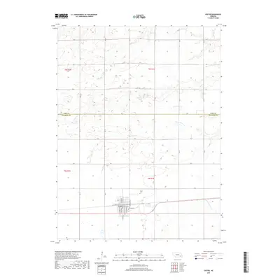
2017 Map of Exeter
USGS Topo · Published 2017About this map
Exeter serves as the primary hub of this eastern Nebraska landscape, situated along the border of York and Fillmore Counties. The town's grid is well-defined by a network of local thoroughfares such as S Exeter Ave and E Seneca St, reflecting a community deeply tied to the surrounding agricultural plains. North of the town center, the Exeter Cem sits quietly, a key point of interest for those researching local family histories. The drainage patterns of the region are marked by several seasonal and permanent waterways, including Antelope Cr and Indian Cr, which cut through the high-plains terrain. In the eastern portion of the survey, the N Fork Johnson Cr and S Fork Johnson Cr converge, illustrating the hydrological network that has shaped the land use and field boundaries of this rural sector.
Find a feature on this map
32 named features on this map. Tap any name to fly to it.
Don’t see what you’re looking for? This feature index may not catch every label — zoom into the map to look around manually.
Map Details
Editions of this 2017 Exeter Map
This is the sole edition of this map. No revisions or reprints were ever made.
Other maps of this area

1898 · York
USGS Topo · 1:125,000

1899 · York
USGS Topo · 1:125,000

1934 · Utica
USGS Topo · 1:62,500

1937 · Utica
USGS Topo · 1:62,500

1955 · Lincoln
USGS Topo · 1:250,000

1957 · Lincoln
USGS Topo · 1:250,000

1958 · Lincoln
USGS Topo · 1:250,000
1966 · Friend
USGS Topo · 1:24,000
1966 · Beaver Crossing
USGS Topo · 1:24,000
1966 · Friend SE
USGS Topo · 1:24,000