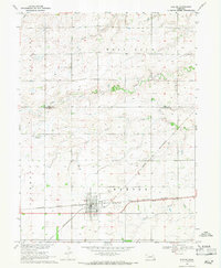
1969 Map of Exeter
USGS Topo · Published 1971About this map
The village of Exeter serves as a central hub on this Nebraska plains landscape, where the Burlington Northern and Chicago and North Western railroads intersect. This intersection defines the local geography, anchoring the grid of the town near the Exeter Cem. The surrounding terrain is primarily agricultural, marked by the drainage patterns of Antelope Creek to the north and the various branches of Johnson Creek to the south. A notable modern addition to the rural landscape is the Flying J Landing Strip, located west of the main settlement. The map provides a look at the township structures of McFadden, West Blue, and Fairmont, illustrating how section lines and farmstead placements were established relative to the primary watercourses and rail lines of Fillmore and York counties.
Find a feature on this map
16 named features on this map. Tap any name to fly to it.
Don’t see what you’re looking for? This feature index may not catch every label — zoom into the map to look around manually.
Map Details
Editions of this 1969 Exeter Map
This is the sole edition of this map. No revisions or reprints were ever made.
Other maps of this area

1898 · York
USGS Topo · 1:125,000

1899 · York
USGS Topo · 1:125,000

1934 · Utica
USGS Topo · 1:62,500

1937 · Utica
USGS Topo · 1:62,500

1955 · Lincoln
USGS Topo · 1:250,000

1957 · Lincoln
USGS Topo · 1:250,000

1958 · Lincoln
USGS Topo · 1:250,000
1966 · Friend
USGS Topo · 1:24,000
1966 · Beaver Crossing
USGS Topo · 1:24,000
1966 · Friend SE
USGS Topo · 1:24,000