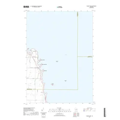
2018 Map of Fahrney Point
USGS Topo · Published 2018About this map
Lake Winnebago defines the eastern half of this landscape, its vast shoreline shaped by a series of distinct points and offshore hazards. The western shore is characterized by residential development along Lakeshore Dr and Fond Du Lac Rd, where the settlement of Decorah Beach sits at the water's edge. This 2018 survey captures the intricate boundary of the lake from Streich Point in the north down to Little Point, documenting a transition from shoreline properties to the inland agricultural fields of southern Winnebago County. Local history and genealogy interest is anchored by the presence of Oaklawn Cem and Knack Cem, while the lake's topography includes notable underwater features such as Long Point Reef and Abraham Reef. The map provides an exact record of the transportation network, including rural corridors like Co Rd Z and Lone Elm Ave, connecting the lakeside communities to the interior landscape.
Find a feature on this map
32 named features on this map. Tap any name to fly to it.
Don’t see what you’re looking for? This feature index may not catch every label — zoom into the map to look around manually.
Map Details
Editions of this 2018 Fahrney Point Map
This is the sole edition of this map. No revisions or reprints were ever made.
Other maps of this area

1910 · Fond du Lac
USGS Topo · 1:62,500

1911 · Neenah
USGS Topo · 1:62,500

1955 · Neenah
USGS Topo · 1:62,500

1955 · Fond Du Lac
USGS Topo · 1:62,500

1955 · Fond Du Lac
USGS Topo · 1:24,000

1955 · Green Bay
USGS Topo · 1:250,000

1956 · Rosendale
USGS Topo · 1:62,500

1957 · Madison
USGS Topo · 1:250,000

1960 · Madison
USGS Topo · 1:250,000

1961 · Oshkosh
USGS Topo · 1:24,000