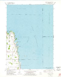
1974 Map of Fahrney Point
USGS Topo · Published 1978About this map
Lake Winnebago dominates this 1970s survey, illustrating the mid-century development of the western shoreline south of Oshkosh. The landscape is characterized by a series of residential and recreational developments concentrated along the water's edge, including Decorah Beach and Point Comfort. Inland, the map reveals a transition into agricultural land, marked by a precise grid of rural roads such as Koelpin Road and Lone Elm Ave. Local landmarks like the Jesuit Retreat near Fahrney Point and Oaklawn Cem provide specific points of interest for genealogists and local historians. The presence of numerous boat ramps and Willow Harbor underscores the area's long-standing identity as a hub for water-based recreation, while offshore features like Long Point Reef and Abraham Reef reflect the complex bathymetry that has historically challenged navigators on Wisconsin's largest inland lake.
Find a feature on this map
36 named features on this map. Tap any name to fly to it.
Don’t see what you’re looking for? This feature index may not catch every label — zoom into the map to look around manually.
Map Details
Editions of this 1974 Fahrney Point Map
This is the sole edition of this map. No revisions or reprints were ever made.
Other maps of this area

1910 · Fond du Lac
USGS Topo · 1:62,500

1911 · Neenah
USGS Topo · 1:62,500

1955 · Neenah
USGS Topo · 1:62,500

1955 · Fond Du Lac
USGS Topo · 1:62,500

1955 · Fond Du Lac
USGS Topo · 1:24,000

1955 · Green Bay
USGS Topo · 1:250,000

1956 · Rosendale
USGS Topo · 1:62,500

1957 · Madison
USGS Topo · 1:250,000

1960 · Madison
USGS Topo · 1:250,000

1961 · Oshkosh
USGS Topo · 1:24,000