1967 Map of Fail Ranch
USGS Topo · Published 1970About this map
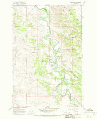
The Musselshell River carves a winding path through the heart of the Montana ranchlands, serving as the primary geographic feature that defines this landscape. This mid-century survey illustrates the rural infrastructure along the border of Petroleum and Garfield counties, where isolated outposts like Fail Ranch and Moss Ranch anchor the river bends. The map provides a detailed view of the Cat Creek Oil Field, documenting the industrial footprint of petroleum extraction through numerous marked Drill Holes and supporting Gravel Pits. A dense network of seasonal drainages, including Wagner Coulee, Long Coulee, and Jackson Coulee, dissects the terrain, revealing the complex erosion patterns characteristic of the northern plains. This record is particularly valuable for tracing historical property boundaries and the spatial relationship between water sources and early energy exploration.
Find a feature on this map
16 named features on this map. Tap any name to fly to it.
Don’t see what you’re looking for? This feature index may not catch every label — zoom into the map to look around manually.
Map Details
Editions of this 1967 Fail Ranch Map
This is the sole edition of this map. No revisions or reprints were ever made.
Other maps of this area

1954 · Jordan
USGS Topo · 1:250,000

1954 · Forsyth
USGS Topo · 1:250,000

1954 · Roundup
USGS Topo · 1:250,000

1954 · Lewistown
USGS Topo · 1:250,000

1956 · Jordan
USGS Topo · 1:250,000

1957 · Forsyth
USGS Topo · 1:250,000

1958 · Jordan
USGS Topo · 1:250,000

1958 · Roundup
USGS Topo · 1:250,000

1958 · Forsyth
USGS Topo · 1:250,000

1959 · Lewistown
USGS Topo · 1:250,000