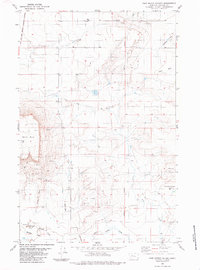
1983 Map of Fair Haven Colony
USGS Topo · Published 1985About this map
Fair Haven Colony serves as a primary settlement in this portion of Cascade County, situated in a landscape defined by the varied hydrology of Dry Fork and Little Muddy Creek. The western edge of the map is defined by the Old Fort Shaw Military Reservation Boundary, a significant historical line marking the extent of the 19th-century frontier outpost. The terrain transitions from the low-lying Muddy Flats to the prominent heights of Square Butte and Taft Hill. Rural infrastructure is evident through several specialized landmarks, including a Landing Strip, isolated wells and water tanks, and a Gravel Pit near the colony, reflecting the local agricultural and light industrial activity of the late 1970s and early 1980s.
Find a feature on this map
16 named features on this map. Tap any name to fly to it.
Don’t see what you’re looking for? This feature index may not catch every label — zoom into the map to look around manually.
Map Details
Editions of this 1983 Fair Haven Colony Map
2 editions found
Other maps of this area

1886 · Great Falls
USGS Topo · 1:250,000

1949 · Cascade
USGS Topo · 1:62,500

1949 · Vaughn
USGS Topo · 1:62,500

1950 · Fairfield
USGS Topo · 1:62,500

1951 · Cascade
USGS Topo · 1:62,500

1952 · Vaughn
USGS Topo · 1:62,500

1954 · Great Falls
USGS Topo · 1:250,000

1957 · Great Falls
USGS Topo · 1:250,000

1960 · Simms
USGS Topo · 1:62,500

1976 · Great Falls North
USGS Topo · 1:100,000