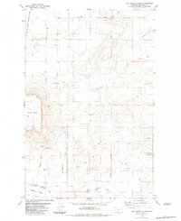
1983 Map of Fair Haven Colony
USGS Topo · Published 1983About this map
The Fair Haven Colony serves as a primary point of human settlement on this High Plains landscape, situated east of the Old Fort Shaw Military Reservation Boundary. The terrain is defined by prominent topographical rises and drainage patterns, including the plateau of Square Butte to the west and Taft Hill to the northeast. A network of ephemeral and perennial watercourses like Fourmile Creek and the Dry Fork carve through the plains, while the Little Muddy Creek winds through the southern Muddy Flats. Evidence of local infrastructure and resource extraction is visible through the presence of a Landing Strip, a Gravel Pit, and various water tanks. The Principal Meridian runs vertically through the center of the quadrangle, anchoring the grid of this rural Montana landscape.
Find a feature on this map
17 named features on this map. Tap any name to fly to it.
Don’t see what you’re looking for? This feature index may not catch every label — zoom into the map to look around manually.
Map Details
Editions of this 1983 Fair Haven Colony Map
2 editions found
Other maps of this area

1886 · Great Falls
USGS Topo · 1:250,000

1949 · Cascade
USGS Topo · 1:62,500

1949 · Vaughn
USGS Topo · 1:62,500

1950 · Fairfield
USGS Topo · 1:62,500

1951 · Cascade
USGS Topo · 1:62,500

1952 · Vaughn
USGS Topo · 1:62,500

1954 · Great Falls
USGS Topo · 1:250,000

1957 · Great Falls
USGS Topo · 1:250,000

1960 · Simms
USGS Topo · 1:62,500

1976 · Great Falls North
USGS Topo · 1:100,000