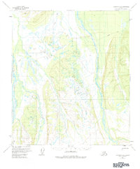
1973 Map of Fairbanks A-6
USGS Topo · Published 1984About this map
The Teklanika River flows northward through this Interior Alaska landscape, flanked by the braided channels of the Sushana River and the Toklat River. Based on aerial photography from the early 1950s, the map reveals a wilderness largely devoid of permanent settlement, characterized by the dynamic movement of water across wide gravel beds. The presence of the Winter Trail snaking through the northern and eastern sections suggests the seasonal nature of travel in this region, where frozen ground once provided the primary means of passage through the lowlands. Survey markers like VABM Nika and VABM Rick provide the only human-made navigational points in a terrain dominated by glacial drainage patterns and unmarked land lines predetermined by the Bureau of Land Management.
Find a feature on this map
6 named features on this map. Tap any name to fly to it.
Don’t see what you’re looking for? This feature index may not catch every label — zoom into the map to look around manually.
Map Details
Editions of this 1973 Fairbanks A-6 Map
This is the sole edition of this map. No revisions or reprints were ever made.
Other maps of this area

1948 · Kantishna River
USGS Topo · 1:250,000

1949 · Fairbanks B-5
USGS Topo · 1:63,360

1950 · Fairbanks
USGS Topo · 1:250,000

1950 · Fairbanks A-5
USGS Topo · 1:63,360

1950 · Fairbanks B-5
USGS Topo · 1:63,360

1951 · Healy
USGS Topo · 1:250,000

1951 · Kantishna River
USGS Topo · 1:250,000

1951 · Fairbanks B-5
USGS Topo · 1:63,360

1951 · Fairbanks
USGS Topo · 1:250,000

1951 · Fairbanks A-5
USGS Topo · 1:63,360