
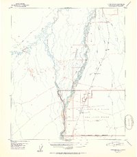
1951 Map of Fairbanks B-5
USGS Topo · Published 1951About this map
Braided waterways and seasonal transportation corridors define this interior landscape south of Fairbanks in the early 1950s. The Nenana River and Teklanika River dominate the western terrain, their shifting channels giving rise to features like Seventeenmile Slough and Lost Slough. This survey captures a moment of military transition, documenting the Clear Air Force Auxiliary Field (Inactive) and its associated airstrip alongside the Military Reservation Boundary.
Find a feature on this map
20 named features on this map. Tap any name to fly to it.
Don’t see what you’re looking for? This feature index may not catch every label — zoom into the map to look around manually.
Map Details
Editions of this 1951 Fairbanks B-5 Map
2 editions found
Other maps of this area

1949 · Fairbanks B-5
USGS Topo · 1:63,360

1949 · Fairbanks B-4
USGS Topo · 1:63,360

1950 · Fairbanks
USGS Topo · 1:250,000

1950 · Fairbanks C-5
USGS Topo · 1:63,360

1950 · Fairbanks A-5
USGS Topo · 1:63,360

1950 · Fairbanks C-4
USGS Topo · 1:63,360

1950 · Fairbanks A-4
USGS Topo · 1:63,360

1950 · Fairbanks B-5
USGS Topo · 1:63,360

1951 · Fairbanks
USGS Topo · 1:250,000

1951 · Fairbanks A-5
USGS Topo · 1:63,360