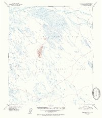
1952 Map of Fairbanks C-2
USGS Topo · Published 1952About this map
The interior Alaskan wilderness near Fairbanks was largely defined by Cold War-era military operations at the start of the 1950s. This survey, based on 1949 aerial photography, highlights the massive footprint of the Ladd Air Force Base and its associated Bombing and Gunnery Range, which dominate the central and southern portions of the landscape. The terrain is characterized by a complex network of waterways, including the winding Salchaket Slough in the north and several drainages such as Clear Creek and Willow Creek that thread through the lowlands. A significant overland route, the Bonnifield Trail, cuts through the range, passing just east of the prominent Clear Creek Butte. This intersection of military utility and traditional wilderness travel routes illustrates the dual nature of Alaska's mid-century development, where strategic defense requirements frequently overlaid the natural topography of the Tanana Valley.
Find a feature on this map
8 named features on this map. Tap any name to fly to it.
Don’t see what you’re looking for? This feature index may not catch every label — zoom into the map to look around manually.
Map Details
Editions of this 1952 Fairbanks C-2 Map
2 editions found

Other maps of this area

1949 · Fairbanks D-1
USGS Topo · 1:62,500

1949 · Fairbanks D-2
USGS Topo · 1:62,500

1949 · Fairbanks C-1
USGS Topo · 1:63,360

1949 · Fairbanks D-3
USGS Topo · 1:63,360

1949 · Fairbanks C-2
USGS Topo · 1:63,360

1949 · Fairbanks B-3
USGS Topo · 1:63,360

1950 · Fairbanks
USGS Topo · 1:250,000

1950 · Fairbanks C-3
USGS Topo · 1:63,360

1950 · Fairbanks C-1
USGS Topo · 1:63,360

1950 · Fairbanks B-2
USGS Topo · 1:63,360