
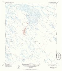
1952 Map of Fairbanks C-2
USGS Topo · Published 1952About this map
Ladd Air Force Base dominates the northern portion of this landscape during the early Cold War era, serving as a critical strategic installation in the Alaskan interior. The terrain is characterized by a complex network of waterways, including Salchaket Slough and the winding course of Clear Creek. To the south, a large Bombing and Gunnery Range indicates the area's primary mid-century use for military training and maneuvers. A distinctive topographical landmark, Clear Creek Butte, rises above the surrounding lowlands, providing a clear point of reference for the historic Bonnifield Trail which cuts through the center of the sheet. This map captures the intersection of wilderness and federal military expansion, where traditional routes like the Bonnifield intersect with restricted zones and hydrological features like Willow Creek and Dry Creek.
Find a feature on this map
8 named features on this map. Tap any name to fly to it.
Don’t see what you’re looking for? This feature index may not catch every label — zoom into the map to look around manually.
Map Details
Editions of this 1952 Fairbanks C-2 Map
2 editions found
Other maps of this area

1949 · Fairbanks D-1
USGS Topo · 1:62,500

1949 · Fairbanks D-2
USGS Topo · 1:62,500

1949 · Fairbanks C-1
USGS Topo · 1:63,360

1949 · Fairbanks D-3
USGS Topo · 1:63,360

1949 · Fairbanks C-2
USGS Topo · 1:63,360

1949 · Fairbanks B-3
USGS Topo · 1:63,360

1950 · Fairbanks
USGS Topo · 1:250,000

1950 · Fairbanks C-3
USGS Topo · 1:63,360

1950 · Fairbanks C-1
USGS Topo · 1:63,360

1950 · Fairbanks B-2
USGS Topo · 1:63,360