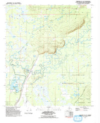
1992 Map of Fairbanks D-1 SE
USGS Topo · Published 1992About this map
The Chena River dominates this interior Alaskan landscape as it meanders through a complex network of sloughs and wetlands, including Jenny Slough and Mullen Slough. By the early 1990s, the area south of Chena Hot Springs Road shows significant civil engineering and land management, centered around the Chena Lakes Recreation Site. A prominent Levee system and structures like the Floodgate and Gaging Station indicate sophisticated flood control measures along the river's path.
Find a feature on this map
21 named features on this map. Tap any name to fly to it.
Don’t see what you’re looking for? This feature index may not catch every label — zoom into the map to look around manually.
Map Details
Editions of this 1992 Fairbanks D-1 SE Map
This is the sole edition of this map. No revisions or reprints were ever made.
Other maps of this area

1949 · Fairbanks D-1
USGS Topo · 1:62,500

1949 · Fairbanks C-1
USGS Topo · 1:63,360

1949 · Big Delta C-6
USGS Topo · 1:63,360

1950 · Fairbanks
USGS Topo · 1:250,000

1950 · Big Delta
USGS Topo · 1:250,000

1950 · Big Delta D-6
USGS Topo · 1:63,360

1950 · Fairbanks C-1
USGS Topo · 1:63,360

1951 · Big Delta
USGS Topo · 1:250,000

1951 · Fairbanks
USGS Topo · 1:250,000

1952 · Big Delta C-6
USGS Topo · 1:63,360