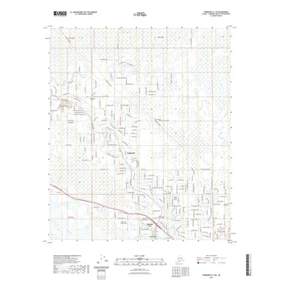
2021 Map of Fairbanks D-1 SW
USGS Topo · Published 2021About this map
The Alaska Pipeline cuts a north-south path through this Fairbanks-area landscape, a defining industrial feature of the modern Interior. In the south, the city of North Pole serves as a residential and commercial anchor, with neighborhoods like Highland Park positioned near the confluence of the Chena Slough and Thirtymile Slough. The settlement of Badger sits centrally, surrounded by a complex network of local roads such as Badger Road and Peede Road.
Find a feature on this map
38 named features on this map. Tap any name to fly to it.
Don’t see what you’re looking for? This feature index may not catch every label — zoom into the map to look around manually.
Map Details
Editions of this 2021 Fairbanks D-1 SW Map
This is the sole edition of this map. No revisions or reprints were ever made.
Other maps of this area

1949 · Fairbanks D-1
USGS Topo · 1:62,500

1949 · Fairbanks D-2
USGS Topo · 1:62,500

1949 · Fairbanks C-1
USGS Topo · 1:63,360

1949 · Fairbanks C-2
USGS Topo · 1:63,360

1950 · Fairbanks
USGS Topo · 1:250,000

1950 · Fairbanks C-1
USGS Topo · 1:63,360

1951 · Fairbanks
USGS Topo · 1:250,000

1952 · Fairbanks C-2
USGS Topo · 1:63,360

1952 · Fairbanks D-2
USGS Topo · 1:63,360
1952 · Fairbanks C-1
USGS Topo · 1:63,360