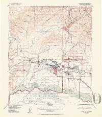
1952 Map of Fairbanks D-2
USGS Topo · Published 1952About this map
Fairbanks and its surrounding river-bound geography are captured during a period of significant post-war expansion and military integration. The Chena River and Noyes Slough frame the urban center, including the distinctive Garden Island area and the early footprint of Ladd Air Force Base to the east. To the west, the U S Agricultural Experiment Station and the settlement of College indicate the academic and research foundations of the region, while the Alaska Railroad and arterial routes like the Steese Highway connect the interior to the wider territory. The landscape is a complex network of gold-mining legacy and emerging modern infrastructure, with ditches and tailings scattered near names like Gold Hill and Ester Dome, reflecting the enduring impact of the mineral industry on the Alaskan interior.
Find a feature on this map
79 named features on this map. Tap any name to fly to it.
Don’t see what you’re looking for? This feature index may not catch every label — zoom into the map to look around manually.
Map Details
Editions of this 1952 Fairbanks D-2 Map
2 editions found

Other maps of this area

1945 · Livengood
USGS Topo · 1:250,000

1949 · Fairbanks D-1
USGS Topo · 1:62,500

1949 · Fairbanks D-2
USGS Topo · 1:62,500

1949 · Fairbanks C-1
USGS Topo · 1:63,360

1949 · Fairbanks D-3
USGS Topo · 1:63,360

1949 · Fairbanks C-2
USGS Topo · 1:63,360

1950 · Fairbanks
USGS Topo · 1:250,000

1950 · Fairbanks C-3
USGS Topo · 1:63,360

1950 · Fairbanks C-1
USGS Topo · 1:63,360

1950 · Fairbanks D-3
USGS Topo · 1:63,360