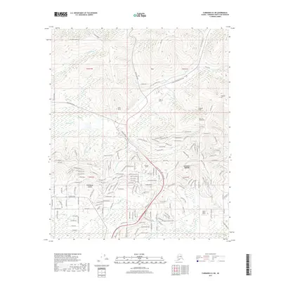
2017 Map of Fairbanks D-2 NE
USGS Topo · Published 2017About this map
The Alaska Pipeline snakes through this Fairbanks interior landscape, a defining industrial feature that crosses the terrain near Fox. This 2017 survey details a region where historic mining routes and modern infrastructure overlap, as seen where the Old Chatanika Trail meets the Elliott Highway. Residential expansion is evident in the dense street networks of Steele Creek and the Farmers Loop area, while the upland topography is marked by notable heights like Mt Lulu Fairbanks and Tungsten Hill. The map traces numerous watercourses, including Goldstream Cr and Steele Cr, which have long drawn prospectors to the various gulches like Irish Gulch and Silver Gulch. Local transportation is further supported by the Moen's Ranch Airport, tucked near the southern edge of the quadrangle near Liwa Lake.
Find a feature on this map
183 named features on this map. Tap any name to fly to it.
Don’t see what you’re looking for? This feature index may not catch every label — zoom into the map to look around manually.
Map Details
Editions of this 2017 Fairbanks D-2 NE Map
This is the sole edition of this map. No revisions or reprints were ever made.
Other maps of this area

1945 · Livengood
USGS Topo · 1:250,000

1949 · Fairbanks D-1
USGS Topo · 1:62,500

1949 · Fairbanks D-2
USGS Topo · 1:62,500

1950 · Fairbanks
USGS Topo · 1:250,000

1951 · Fairbanks
USGS Topo · 1:250,000

1951 · Livengood
USGS Topo · 1:250,000

1952 · Fairbanks D-2
USGS Topo · 1:63,360
1952 · Fairbanks D-1
USGS Topo · 1:63,360

1952 · Fairbanks
USGS Topo · 1:250,000

1952 · Livengood A-2
USGS Topo · 1:63,360