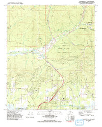
1992 Map of Fairbanks D-2 NE
USGS Topo · Published 1992About this map
Gold mining history and modern scientific infrastructure intersect in this interior Alaska landscape north of Fairbanks. The settlement of Fox sits at a geographic crossroads, surrounded by extensive tailings, mines, and a Dredge that speak to the region's intensive mineral extraction era. Remnants of former communities are documented at Glenn Creek, Engineer, and Gilmore, while an Old Railroad Grade and Abandoned Railroad Grade trace the historical transportation routes that once served these camps.
Find a feature on this map
69 named features on this map. Tap any name to fly to it.
Don’t see what you’re looking for? This feature index may not catch every label — zoom into the map to look around manually.
Map Details
Editions of this 1992 Fairbanks D-2 NE Map
This is the sole edition of this map. No revisions or reprints were ever made.
Other maps of this area

1945 · Livengood
USGS Topo · 1:250,000

1949 · Fairbanks D-1
USGS Topo · 1:62,500

1949 · Fairbanks D-2
USGS Topo · 1:62,500

1950 · Fairbanks
USGS Topo · 1:250,000

1951 · Fairbanks
USGS Topo · 1:250,000

1951 · Livengood
USGS Topo · 1:250,000

1952 · Fairbanks D-2
USGS Topo · 1:63,360
1952 · Fairbanks D-1
USGS Topo · 1:63,360

1952 · Fairbanks
USGS Topo · 1:250,000

1952 · Livengood A-2
USGS Topo · 1:63,360