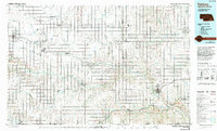
1985 Map of Fairbury
USGS Topo · Published 1994About this map
Fairbury serves as the primary hub in this mid-1980s landscape, positioned near the confluence of the Little Blue River and Rock Creek. The map documents a predominantly agricultural region across southeastern Nebraska and northern Kansas, where a dense grid of section lines and township boundaries organizes the prairie. Natural conservation and history are preserved at the Rock Creek Station State Historical Park and the Alexandria State Wildlife Management Area, reflecting a balance between land use and habitat protection. Along the West Blue River and Big Sandy Creek, smaller settlements like Hebron, Deshler, and Alexandria follow the drainage patterns and transportation corridors. An Old Railroad Grade north of Fairbury and Jansen points to the evolving rail infrastructure of the late 20th century, while various waterfowl production areas emphasize the importance of the Central Flyway through this corridor.
Find a feature on this map
65 named features on this map. Tap any name to fly to it.
Don’t see what you’re looking for? This feature index may not catch every label — zoom into the map to look around manually.
Map Details
Editions of this 1985 Fairbury Map
2 editions found
Other maps of this area

1889 · Marysville
USGS Topo · 1:125,000

1892 · Concordia
USGS Topo · 1:125,000

1893 · Washington
USGS Topo · 1:125,000

1894 · Mankato
USGS Topo · 1:125,000

1894 · Marysville
USGS Topo · 1:125,000

1897 · Lincoln
USGS Topo · 1:125,000

1898 · York
USGS Topo · 1:125,000

1898 · Superior
USGS Topo · 1:125,000

1898 · Hebron
USGS Topo · 1:125,000

1898 · Grand Island
USGS Topo · 1:125,000