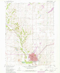
1960 Map of Fairbury
USGS Topo · Published 1980About this map
The Little Blue River valley serves as the central corridor for this 1960s study, where the convergence of the Union Pacific and the Chicago Rock Island and Pacific railroads underscores the city of Fairbury as a vital regional hub. The map captures an era of established educational and civic infrastructure, documenting numerous rural schoolhouses such as Maple Grove Sch and Gardener Sch that once served the surrounding Richland and Fairbury townships. Local industry is marked by several Quarries and a Gravel Pit near the river, illustrating the area's reliance on its geological resources.
Find a feature on this map
43 named features on this map. Tap any name to fly to it.
Don’t see what you’re looking for? This feature index may not catch every label — zoom into the map to look around manually.
Map Details
Editions of this 1960 Fairbury Map
2 editions found
Other maps of this area

1955 · Lincoln
USGS Topo · 1:250,000

1957 · Lincoln
USGS Topo · 1:250,000

1958 · Lincoln
USGS Topo · 1:250,000

1960 · Fairbury SW
USGS Topo · 1:24,000

1960 · Reynolds
USGS Topo · 1:24,000

1960 · Western SW
USGS Topo · 1:24,000

1960 · Fairbury
USGS Topo · 1:24,000
1960 · Gladstone
USGS Topo · 1:24,000

1960 · Daykin
USGS Topo · 1:24,000

1961 · Western SE
USGS Topo · 1:24,000