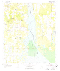
1955 Map of Fairchild
USGS Topo · Published 1975About this map
Lake Seminole dominates the central landscape of this mid-1950s survey, marking the state line between Florida and Georgia along the Chattahoochee River. The map captures the transitional character of Seminole County and Jackson County, where the sprawling waterway meets a terrestrial environment dotted with family-named landmarks and rural institutions. Small communities like Fairchild and Drakes Still anchor the eastern shore, while the western side is defined by an intricate network of sinkhole ponds such as Buttonwood Pond and Half Moon Pond.
Find a feature on this map
43 named features on this map. Tap any name to fly to it.
Don’t see what you’re looking for? This feature index may not catch every label — zoom into the map to look around manually.
Map Details
Editions of this 1955 Fairchild Map
2 editions found
Other maps of this area

1952 · Cypress
USGS Topo · 1:24,000

1952 · Dellwood
USGS Topo · 1:24,000

1952 · Bascom
USGS Topo · 1:24,000

1954 · Steam Mill
USGS Topo · 1:24,000

1954 · Sneads
USGS Topo · 1:24,000

1954 · Desser
USGS Topo · 1:24,000

1954 · Tallahassee
USGS Topo · 1:250,000

1955 · Fairchild
USGS Topo · 1:24,000

1955 · Reynoldsville
USGS Topo · 1:24,000

1955 · Chattahoochee
USGS Topo · 1:24,000