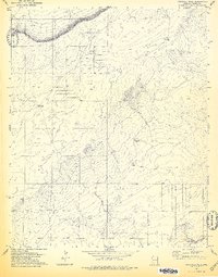
1978 Map of Fairchild Well
USGS Topo · Published 1978About this map
Petroglyphs located in the southern portion of the quadrangle suggest a deep cultural history in this Apache County landscape, even as the 1970s land use was defined by livestock and water management. The terrain is marked by essential water sources for ranching, including Fairchild Well, Bar-N Well, and Mesa Well. A network of fence and field lines, visible from aerial photography but not checked in the field, partitions the open range between the townships of T 18 N and T 19 N. This survey captures the region before extensive modern development, highlighting a landscape where a seasonal Wash and isolated wells were the primary infrastructure for those working the high desert plains.
Find a feature on this map
7 named features on this map. Tap any name to fly to it.
Don’t see what you’re looking for? This feature index may not catch every label — zoom into the map to look around manually.
Map Details
Editions of this 1978 Fairchild Well Map
This is the sole edition of this map. No revisions or reprints were ever made.
Other maps of this area

1886 · St Johns
USGS Topo · 1:250,000

1886 · Fort Defiance
USGS Topo · 1:250,000

1892 · Fort Defiance
USGS Topo · 1:250,000

1892 · St Johns
USGS Topo · 1:250,000

1954 · Saint Johns
USGS Topo · 1:250,000

1954 · Gallup
USGS Topo · 1:250,000

1957 · Saint Johns
USGS Topo · 1:250,000

1958 · Gallup
USGS Topo · 1:250,000

1958 · Saint Johns
USGS Topo · 1:250,000

1959 · Gallup
USGS Topo · 1:250,000