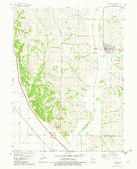
1981 Map of Fairfax
USGS Topo · Published 1982About this map
The Tarkio River flows southward through the eastern half of this Atchison County landscape, defining the agricultural and industrial layout of Fairfax. The town serves as a local hub, featuring sewage disposal ponds and a gaging station along the riverbanks. The Burlington Northern railroad corridor cuts diagonally across the southwestern corner, connecting the smaller settlements of Milton and Corning to the wider regional trade network.
Find a feature on this map
24 named features on this map. Tap any name to fly to it.
Don’t see what you’re looking for? This feature index may not catch every label — zoom into the map to look around manually.
Map Details
Editions of this 1981 Fairfax Map
This is the sole edition of this map. No revisions or reprints were ever made.
Other maps of this area

1915 · Falls City
USGS Topo · 1:62,500

1915 · Nemaha
USGS Topo · 1:62,500

1920 · Craig
USGS Topo · 1:62,500

1936 · Fairfax
USGS Topo · 1:24,000

1939 · Tarkio
USGS Topo · 1:62,500

1939 · Nemaha
USGS Topo · 1:62,500

1940 · Tarkio
USGS Topo · 1:62,500

1941 · Tarkio
USGS Topo · 1:62,500

1949 · Nemaha
USGS Topo · 1:62,500

1955 · Nebraska City
USGS Topo · 1:250,000