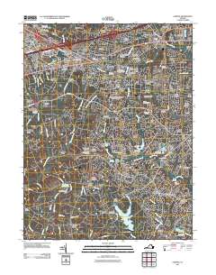
2011 Map of Fairfax
USGS Topo · Published 2011About this map
Fairfax and its surrounding suburbs appear as a dense network of residential estates and institutional hubs in the early 21st century. The map highlights the sprawling George Mason University Fairfax Campus at the heart of the region, surrounded by established communities like Mantua, Lord Fairfax Estates, and Oakton. The landscape is defined by its water management systems, featuring numerous reservoirs and flood control structures including Lake Royal, Lake Braddock, and the Burke Lake Dam.
Find a feature on this map
140 named features on this map. Tap any name to fly to it.
Don’t see what you’re looking for? This feature index may not catch every label — zoom into the map to look around manually.
Map Details
Editions of this 2011 Fairfax Map
This is the sole edition of this map. No revisions or reprints were ever made.
Other maps of this area

1890 · Mt. Vernon
USGS Topo · 1:125,000

1891 · Mt. Vernon
USGS Topo · 1:125,000

1894 · Mt. Vernon
USGS Topo · 1:125,000

1897 · Mt. Vernon
USGS Topo · 1:125,000

1900 · Washington
USGS Topo · 1:62,500

1913 · Indian Head
USGS Topo · 1:62,500

1915 · Fairfax
USGS Topo · 1:62,500

1923 · Indian Head
USGS Topo · 1:48,000

1925 · Indian Head
USGS Topo · 1:62,500

1927 · Quantico
USGS Topo · 1:62,500