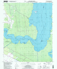
2000 Map of Fairfield NE
USGS Topo · Published 2002About this map
Alligator River National Wildlife Refuge dominates this coastal landscape at the turn of the 21st century, where the land and water are inextricably linked. The Alligator River and the Intracoastal Waterway serve as the primary conduits for transit through the marshy terrain of Tyrrell, Dare, and Hyde counties. Historically significant landings such as Gum Neck Landing and Grapevine Landing indicate the long-standing importance of water access for the Gum Neck area.
Find a feature on this map
29 named features on this map. Tap any name to fly to it.
Don’t see what you’re looking for? This feature index may not catch every label — zoom into the map to look around manually.
Map Details
Editions of this 2000 Fairfield NE Map
This is the sole edition of this map. No revisions or reprints were ever made.
Other maps of this area

1943 · Columbia
USGS Topo · 1:125,000

1943 · Roanoke Island
USGS Topo · 1:125,000

1951 · Engelhard West
USGS Topo · 1:24,000

1951 · Engelhard East
USGS Topo · 1:24,000

1951 · Fairfield
USGS Topo · 1:24,000

1953 · Engelhard NW
USGS Topo · 1:24,000

1953 · Buffalo City
USGS Topo · 1:24,000

1953 · Fairfield NE
USGS Topo · 1:24,000

1953 · Scotia
USGS Topo · 1:24,000

1953 · Frying Pan
USGS Topo · 1:24,000