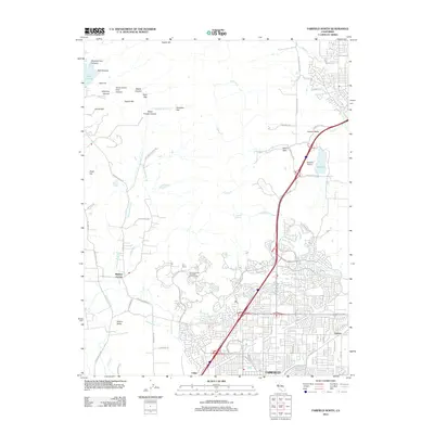
2012 Map of Fairfield North
USGS Topo · Published 2012About this map
Fairfield anchors the southern portion of this landscape, showing a dense residential grid transitioning into the foothills of the Vaca Mountains by 2012. The urban development of northern Solano County is punctuated by significant landmarks like the Rancho Solano Municipal Golf Course and the Vacaville Airport. To the north and west, the terrain opens into the agricultural reaches of Suisun Valley and the winding Gordon Valley Cr, where topographic features such as Ephlin Hill and Lemon Hill overlook the valleys below. Historically significant spots like Mankas Corner and Tolenas mark older settlement nodes, while the northeastern corner is defined by the Lagoon Valley parkland and the waters of Lake Curry. The map captures a mix of suburban expansion and the preserved rural character of northern California's interior coastal range, tracing the path of major thoroughfares like Air Base Pkwy and Travis Blvd.
Find a feature on this map
71 named features on this map. Tap any name to fly to it.
Don’t see what you’re looking for? This feature index may not catch every label — zoom into the map to look around manually.
Map Details
Editions of this 2012 Fairfield North Map
This is the sole edition of this map. No revisions or reprints were ever made.
Other maps of this area

1896 · Carquinez Strait
USGS Topo · 1:62,500

1898 · Karquines
USGS Topo · 1:62,500

1901 · Karquines
USGS Topo · 1:62,500

1902 · Napa
USGS Topo · 1:125,000

1907 · Antioch
USGS Topo · 1:62,500

1908 · Vacaville
USGS Topo · 1:62,500

1908 · Antioch
USGS Topo · 1:62,500

1917 · Wolfskill
USGS Topo · 1:31,680

1917 · Elmira
USGS Topo · 1:31,680
1918 · Denverton
USGS Topo · 1:31,680