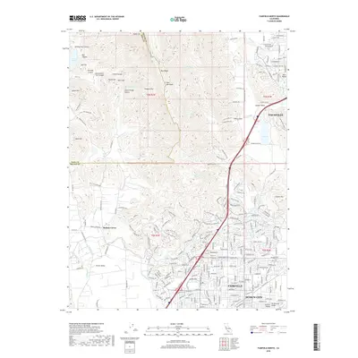
2018 Map of Fairfield North
USGS Topo · Published 2018About this map
Mankas Corner and the surrounding agricultural lands of Suisun Valley occupy the southwestern reaches of this survey, where the valley floor meets the steep rise of the Vaca Mountains. The northern terrain is defined by dramatic elevation changes, including Blue Ridge and Signal Hill, interspersed with named canyons like Stone Trough Canyon and Bull Canyon. In the east, the growing suburban landscapes of Fairfield, Suisun City, and Vacaville contrast with the open space of Lagoon Valley and its namesake Lagoon. Water resources are a central theme here, from the northern Lake Curry reservoir to mineral-rich sites such as Tolenas Springs and the winding course of Soda Springs Cr. This 2018 record shows a landscape where high-density residential development in the south and east presses against the established ranching and open space of the northern ridges and canyons.
Find a feature on this map
235 named features on this map. Tap any name to fly to it.
Don’t see what you’re looking for? This feature index may not catch every label — zoom into the map to look around manually.
Map Details
Editions of this 2018 Fairfield North Map
This is the sole edition of this map. No revisions or reprints were ever made.
Other maps of this area

1896 · Carquinez Strait
USGS Topo · 1:62,500

1898 · Karquines
USGS Topo · 1:62,500

1901 · Karquines
USGS Topo · 1:62,500

1902 · Napa
USGS Topo · 1:125,000

1907 · Antioch
USGS Topo · 1:62,500

1908 · Vacaville
USGS Topo · 1:62,500

1908 · Antioch
USGS Topo · 1:62,500

1917 · Wolfskill
USGS Topo · 1:31,680

1917 · Elmira
USGS Topo · 1:31,680
1918 · Denverton
USGS Topo · 1:31,680