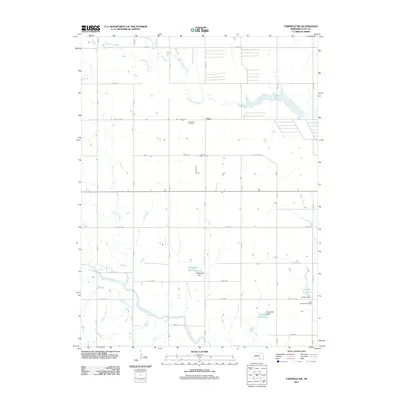
2011 Map of Fairfield NW
USGS Topo · Published 2011About this map
Big Sandy Creek and the Little Blue River define the agricultural drainage of this Clay County landscape. The area is characterized by a grid of rural roads such as Road C and Road 304, punctuated by small-scale water management projects including Nejezchleb Reservoir and Lipovsky Reservoir. These local landmarks, often named for resident families, reflect the ingrained heritage of the plains. For genealogists and local historians, the presence of the Anandale Cemetery near the settlement of Anan and the Saint Aloysius Cemetery in the southeastern quadrant provides essential physical markers of the community's ancestral roots. The map also traces the winding paths of Pawnee Creek, Oak Creek, and Buffalo Creek, illustrating the natural watercourses that have historically influenced land use and settlement patterns in this region of Nebraska.
Find a feature on this map
34 named features on this map. Tap any name to fly to it.
Don’t see what you’re looking for? This feature index may not catch every label — zoom into the map to look around manually.
Map Details
Editions of this 2011 Fairfield NW Map
This is the sole edition of this map. No revisions or reprints were ever made.
Other maps of this area

1898 · Superior
USGS Topo · 1:125,000

1898 · Grand Island
USGS Topo · 1:125,000

1955 · Grand Island
USGS Topo · 1:250,000

1957 · Grand Island
USGS Topo · 1:250,000

1958 · Grand Island
USGS Topo · 1:250,000
1960 · Fairfield SE
USGS Topo · 1:24,000

1960 · Deweese
USGS Topo · 1:24,000

1969 · Hastings East
USGS Topo · 1:24,000

1969 · Fairfield NW
USGS Topo · 1:24,000

1969 · Lawrence
USGS Topo · 1:24,000