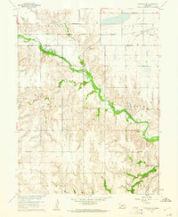
1960 Map of Fairfield SE
USGS Topo · Published 1961About this map
The Little Blue River carves a prominent path through this section of the Nebraska prairie, defining the border between Clay and Nuckolls Counties. This 1960 survey illustrates a rural landscape structured by section-line roads and the Chicago Burlington and Quincy railroad, which skirts the northern edge near Buffalo Creek. The settlement pattern is anchored by a dense network of country schools, such as East Buffalo Sch and Bethany Sch, reflecting the peak of the region's agricultural township system.
Find a feature on this map
23 named features on this map. Tap any name to fly to it.
Don’t see what you’re looking for? This feature index may not catch every label — zoom into the map to look around manually.
Map Details
Editions of this 1960 Fairfield SE Map
This is the sole edition of this map. No revisions or reprints were ever made.
Other maps of this area

1898 · Superior
USGS Topo · 1:125,000

1898 · Hebron
USGS Topo · 1:125,000

1955 · Lincoln
USGS Topo · 1:250,000

1955 · Grand Island
USGS Topo · 1:250,000

1957 · Lincoln
USGS Topo · 1:250,000

1957 · Grand Island
USGS Topo · 1:250,000

1958 · Grand Island
USGS Topo · 1:250,000

1958 · Lincoln
USGS Topo · 1:250,000

1960 · Edgar
USGS Topo · 1:24,000
1960 · Oak
USGS Topo · 1:24,000