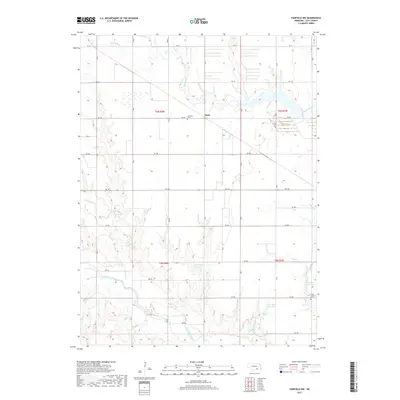
2017 Map of Fairfield NW
USGS Topo · Published 2017About this map
The Little Blue River winds across the southern reaches of this Clay County landscape, defining the topography through its convergence with Oak Cr and Pawnee Cr. This area is characterized by an organized grid of section roads and a network of water management features, including the Nejezchleb Reservoir, Lipovsky Reservoir, and Lambie Reservoir. For those researching local history or genealogy, the small settlement of Anan stands centrally along with the nearby Anandale Cem. Further south, the Saint Aloysius Cem is situated near Buffalo Cr, providing a clear record of established local landmarks. The drainage patterns of Big Sandy Cr and its tributaries further illustrate the agricultural and hydrological development of this Nebraska prairie land in the early 21st century.
Find a feature on this map
25 named features on this map. Tap any name to fly to it.
Don’t see what you’re looking for? This feature index may not catch every label — zoom into the map to look around manually.
Map Details
Editions of this 2017 Fairfield NW Map
This is the sole edition of this map. No revisions or reprints were ever made.
Other maps of this area

1898 · Superior
USGS Topo · 1:125,000

1898 · Grand Island
USGS Topo · 1:125,000

1955 · Grand Island
USGS Topo · 1:250,000

1957 · Grand Island
USGS Topo · 1:250,000

1958 · Grand Island
USGS Topo · 1:250,000
1960 · Fairfield SE
USGS Topo · 1:24,000

1960 · Deweese
USGS Topo · 1:24,000

1969 · Hastings East
USGS Topo · 1:24,000

1969 · Fairfield NW
USGS Topo · 1:24,000

1969 · Lawrence
USGS Topo · 1:24,000