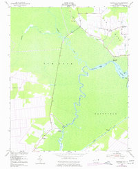
1953 Map of Fairfield NW
USGS Topo · Published 1977About this map
The winding Alligator River forms a serpentine boundary between Tyrrell and Hyde counties, dominating a landscape defined by low-lying wetlands and timbered flats. In the early 1950s, isolated settlements like Kilkenny and Gum Neck maintained their character as quiet coastal outposts, connected by a sparse network of roads that follow the high ground of Long Ridge and Fairfield. Community life centered on local congregations such as Piney Grove Ch, Union Chapel, and Cedar Grove Ch, which stand as vital landmarks for genealogists tracing families in these rural townships. Along the riverbanks, small maritime hubs including Kilkenny Landing and Cherry Ridge Landing suggest a reliance on waterborne commerce and fishing. The southern portion of the survey reveals the engineering of the Pungo Intracoastal Waterway, a critical navigation link that bypassed the complex meanders of the original river channel.
Find a feature on this map
24 named features on this map. Tap any name to fly to it.
Don’t see what you’re looking for? This feature index may not catch every label — zoom into the map to look around manually.
Map Details
Editions of this 1953 Fairfield NW Map
3 editions found
Other maps of this area

1943 · Columbia
USGS Topo · 1:125,000

1951 · Engelhard West
USGS Topo · 1:24,000

1951 · Fairfield
USGS Topo · 1:24,000

1951 · New Lake SE
USGS Topo · 1:24,000

1953 · Fairfield NE
USGS Topo · 1:24,000

1953 · Scotia
USGS Topo · 1:24,000

1953 · Frying Pan
USGS Topo · 1:24,000

1953 · Fairfield NW
USGS Topo · 1:24,000

1953 · Rocky Mount
USGS Topo · 1:250,000

1954 · Rocky Mount
USGS Topo · 1:250,000