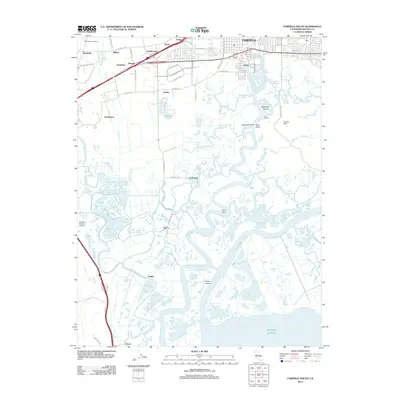
2012 Map of Fairfield South
USGS Topo · Published 2012About this map
Suisun Slough and Montezuma Slough dominate this low-lying landscape, winding through a complex network of wetlands south of Fairfield. This 2012 survey illustrates the transition from the developed corridors around Suisun and Rockville to the expansive tidal marshes of the Pacific Ocean's upper reaches. Small, scattered settlements such as Teal, Cygnus, and Jacksnipe are marked among the waterways, reflecting the area's history of hunting, fishing, and transport along the sloughs. On higher ground, landmarks like the Rockville Public Cem and Garibald Brothers Airport provide points of interest for local historians. The map also traces the drainage patterns of Peltier Slough and Hill Slough, showing how the land has been managed and divided by roads like Cordelia Rd and Hale Ranch Rd.
Find a feature on this map
66 named features on this map. Tap any name to fly to it.
Don’t see what you’re looking for? This feature index may not catch every label — zoom into the map to look around manually.
Map Details
Editions of this 2012 Fairfield South Map
This is the sole edition of this map. No revisions or reprints were ever made.
Other maps of this area

1896 · Carquinez Strait
USGS Topo · 1:62,500

1898 · Karquines
USGS Topo · 1:62,500

1901 · Karquines
USGS Topo · 1:62,500

1902 · Napa
USGS Topo · 1:125,000

1907 · Antioch
USGS Topo · 1:62,500

1908 · Vacaville
USGS Topo · 1:62,500

1908 · Antioch
USGS Topo · 1:62,500

1917 · Elmira
USGS Topo · 1:31,680

1918 · Honker Bay
USGS Topo · 1:31,680
1918 · Denverton
USGS Topo · 1:31,680