
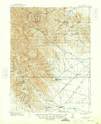
1917 Map of Fairfield
USGS Topo · Published 1917About this map
The Oquirrh Mountains dominate this 1917 survey of the Cedar Valley and Rush Valley regions, revealing a landscape defined by mining operations and early transportation corridors. The western slopes are marked by concentrated industrial activity, including the Chloride Point Mine, the Sacramento Mine, and the Utah Metal Co Tunnel near the settlement of Ophir. These extractive sites are connected to the broader region via the Los Angeles and Salt Lake Road, which traverses the flat terrain of the Cedar Valley to the east.
Find a feature on this map
83 named features on this map. Tap any name to fly to it.
Don’t see what you’re looking for? This feature index may not catch every label — zoom into the map to look around manually.
Map Details
Editions of this 1917 Fairfield Map
2 editions found
Other maps of this area

1885 · Salt Lake
USGS Topo · 1:250,000

1885 · Tooele Valley
USGS Topo · 1:250,000

1915 · Fairfield
USGS Topo · 1:62,500

1918 · Stockton
USGS Topo · 1:62,500

1925 · Ft. Douglas
USGS Topo · 1:125,000

1928 · Ft. Douglas
USGS Topo · 1:125,000

1947 · Fivemile Pass
USGS Topo · 1:62,500
1947 · Goshen Pass
USGS Topo · 1:24,000
1949 · Fivemile Pass
USGS Topo · 1:24,000

1949 · Goshen Pass
USGS Topo · 1:24,000