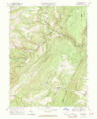
1967 Map of Fairhope
USGS Topo · Published 1970About this map
The Baltimore and Ohio railroad corridor dictates the industrial and social layout of this Somerset County landscape, winding through the valley of Wills Creek past a series of small settlements. The engineering of the rail line is highlighted by the Falls Cut Tunnel near Fairhope, a town established where the tracks meet the confluence of several mountain runs. Further north, Brush Creek flows under a Covered Bridge near Johnsburg, illustrating the transition from transport infrastructure to rural agricultural use.
Find a feature on this map
45 named features on this map. Tap any name to fly to it.
Don’t see what you’re looking for? This feature index may not catch every label — zoom into the map to look around manually.
Map Details
Editions of this 1967 Fairhope Map
Other maps of this area

1898 · Frostburg
USGS Topo · 1:62,500

1899 · Flintstone
USGS Topo · 1:62,500

1900 · Flintstone
USGS Topo · 1:62,500

1901 · Frostburg
USGS Topo · 1:62,500

1908 · Frostburg
USGS Topo · 1:62,500

1923 · Berlin
USGS Topo · 1:48,000

1927 · Hyndman
USGS Topo · 1:62,500

1929 · Berlin
USGS Topo · 1:62,500

1931 · Hyndman
USGS Topo · 1:62,500

1944 · Hyndman
USGS Topo · 1:62,500
Featured Places
- Fairhope Township, PA
- Southampton Township, PA
- Palo Alto, Londonderry Township
- Allegheny Township, PA
- Northampton Township, PA