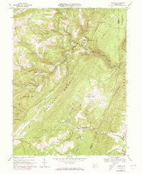
1967 Map of Fairhope
USGS Topo · Published 1973About this map
The Baltimore and Ohio railroad cuts a vital path through the deep gaps of Allegheny Mountain and Savage Mountain on this 1967 survey. Following the winding course of Wills Creek, the rail line passes through the critical Falls Cut Tunnel near the village of Fairhope. This corridor represents a significant engineering feat of the era, where transportation infrastructure was forced to conform to the narrow valleys and steep ridges of the Somerset and Bedford County border. Small mountain communities and agricultural outposts like Glencoe, Bittners Mill, and Johnsburg dot the landscape, often centered around water sources like Brush Creek. The presence of the Union Gospel Mission at Kennells Mill and various unnamed cemeteries near Gladdens provides a clear map for genealogists tracing family histories in these remote Appalachian townships.
Find a feature on this map
40 named features on this map. Tap any name to fly to it.
Don’t see what you’re looking for? This feature index may not catch every label — zoom into the map to look around manually.
Map Details
Editions of this 1967 Fairhope Map
Other maps of this area

1898 · Frostburg
USGS Topo · 1:62,500

1899 · Flintstone
USGS Topo · 1:62,500

1900 · Flintstone
USGS Topo · 1:62,500

1901 · Frostburg
USGS Topo · 1:62,500

1908 · Frostburg
USGS Topo · 1:62,500

1923 · Berlin
USGS Topo · 1:48,000

1927 · Hyndman
USGS Topo · 1:62,500

1929 · Berlin
USGS Topo · 1:62,500

1931 · Hyndman
USGS Topo · 1:62,500

1944 · Hyndman
USGS Topo · 1:62,500
Featured Places
- Fairhope Township, PA
- Southampton Township, PA
- Palo Alto, Londonderry Township
- Allegheny Township, PA
- Northampton Township, PA