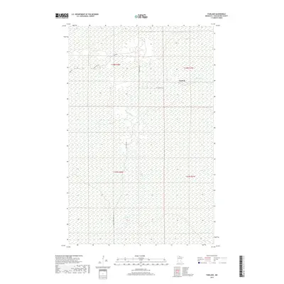
2019 Map of Fairland
USGS Topo · Published 2019About this map
Black River meanders through the heart of this Northwoods landscape in Koochiching County, anchoring a terrain defined by extensive wetlands and isolated timber tracks. The small settlement of Fairland is the primary point of reference, situated where the northern forest gives way to the river's drainage. A network of specialized forest routes, including the Fiero Truck Trl and Black River Rd, provides the only access through the saturated landscape, reflecting the region's reliance on forestry and seasonal travel. This 2019 survey captures the area within several townships, including t158n r27w and t157n r28w, illustrating the intersection of remote water systems and the established Public Land Survey System in one of Minnesota's most sparsely populated reaches.
Find a feature on this map
11 named features on this map. Tap any name to fly to it.
Don’t see what you’re looking for? This feature index may not catch every label — zoom into the map to look around manually.
Map Details
Editions of this 2019 Fairland Map
This is the sole edition of this map. No revisions or reprints were ever made.
Other maps of this area

1919 · Birchdale
USGS Topo · 1:62,500

1919 · I
USGS Topo · 1:62,500

1954 · Roseau
USGS Topo · 1:250,000

1957 · Roseau
USGS Topo · 1:250,000

1958 · Roseau
USGS Topo · 1:250,000

1968 · Birchdale SW
USGS Topo · 1:24,000

1968 · Birchdale SE
USGS Topo · 1:24,000

1968 · Clementson SE
USGS Topo · 1:24,000
1973 · Fairland NE
USGS Topo · 1:24,000
1973 · Giant Pine Campground
USGS Topo · 1:24,000