
1968 Map of Birchdale SW
USGS Topo · Published 1970About this map
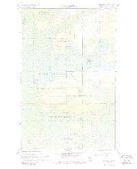
The Red Lake Indian Reservation dominates this northern Minnesota landscape, where extensive wetlands and dense woodlands are crisscrossed by a network of seasonal passages. Surveyed in the late 1960s, the terrain is defined by the Pine Island State Forest and a series of hydrological features including the Wing River and McCloud Creek. The region’s reliance on specialized transportation is evident in the numerous segments of the Winter Trail, which provide access through the swampy lowlands when the ground is frozen. Human activity is largely confined to natural resource extraction, as indicated by a Sandpit in the north and a Gravel Pit further south. Near the eastern boundary, Lost Lake sits as a lonely water body within the sprawling timber and marsh system of Koochiching County.
Find a feature on this map
11 named features on this map. Tap any name to fly to it.
Don’t see what you’re looking for? This feature index may not catch every label — zoom into the map to look around manually.
Map Details
Editions of this 1968 Birchdale SW Map
2 editions found
Other maps of this area

1919 · Birchdale
USGS Topo · 1:62,500

1919 · I
USGS Topo · 1:62,500

1954 · Roseau
USGS Topo · 1:250,000

1957 · Roseau
USGS Topo · 1:250,000

1958 · Roseau
USGS Topo · 1:250,000

1968 · Birchdale SE
USGS Topo · 1:24,000

1968 · Stratton
USGS Topo · 1:24,000
1968 · Birchdale
USGS Topo · 1:24,000

1968 · Border
USGS Topo · 1:24,000

1968 · Clementson SE
USGS Topo · 1:24,000