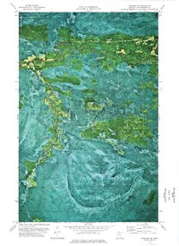
1973 Map of Fairland NE
USGS Topo · Published 1976About this map
Pine Island State Forest dominates this northern Minnesota landscape, where the meandering Black River and its South Fork carve through dense timberland. This 1973 orthophotomap provides a rare visual of the boggy, undeveloped terrain of Koochiching County during the early 1970s. The region is marked by an absence of permanent settlements, defined instead by seasonal access routes such as the Winter Trail and the historic Old Indian Trail. These pathways suggest a landscape where transportation was dictated by the freeze-thaw cycles of the northern wetlands. A lone Radio Tower stands as one of the few modern landmarks in this otherwise remote wilderness, illustrating the era's limited infrastructure in the state's northern reaches.
Find a feature on this map
6 named features on this map. Tap any name to fly to it.
Don’t see what you’re looking for? This feature index may not catch every label — zoom into the map to look around manually.
Map Details
Editions of this 1973 Fairland NE Map
This is the sole edition of this map. No revisions or reprints were ever made.
Other maps of this area

1919 · Birchdale
USGS Topo · 1:62,500

1919 · I
USGS Topo · 1:62,500

1943 · Lindford
USGS Topo · 1:62,500

1954 · Roseau
USGS Topo · 1:250,000

1954 · International Falls
USGS Topo · 1:250,000

1957 · Roseau
USGS Topo · 1:250,000

1957 · International Falls
USGS Topo · 1:250,000

1958 · International Falls
USGS Topo · 1:250,000

1958 · Roseau
USGS Topo · 1:250,000

1968 · Birchdale SW
USGS Topo · 1:24,000