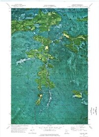
1973 Map of Fairland
USGS Topo · Published 1976About this map
Pine Island State Forest and the Red Lake Indian Reservation converge in this remote orthophotomap of Koochiching County. The landscape is dominated by the winding path of the Black River, which cuts through dense timber and marshland in northern Minnesota. This 1970s record uses aerial imagery to document the isolated settlement at Fairland and the logistical network required for forest management and transportation in this borderland region. Traces of seasonal navigation and industry are evident through the markings for the Winter Trail and a local Gravel Pit. The Indian Pines Lookout Tower stands as a primary landmark for fire surveillance, overlooking a terrain where the boundary lines of state-managed forest and tribal lands intersect.
Find a feature on this map
9 named features on this map. Tap any name to fly to it.
Don’t see what you’re looking for? This feature index may not catch every label — zoom into the map to look around manually.
Map Details
Editions of this 1973 Fairland Map
This is the sole edition of this map. No revisions or reprints were ever made.
Other maps of this area

1919 · Birchdale
USGS Topo · 1:62,500

1919 · I
USGS Topo · 1:62,500

1954 · Roseau
USGS Topo · 1:250,000

1957 · Roseau
USGS Topo · 1:250,000

1958 · Roseau
USGS Topo · 1:250,000

1968 · Birchdale SW
USGS Topo · 1:24,000

1968 · Birchdale SE
USGS Topo · 1:24,000

1968 · Clementson SE
USGS Topo · 1:24,000
1973 · Fairland NE
USGS Topo · 1:24,000
1973 · Giant Pine Campground
USGS Topo · 1:24,000