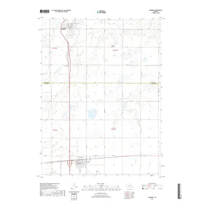
2017 Map of Fairmont
USGS Topo · Published 2017About this map
The BNSF Railway corridor anchors the settlement of Fairmont, where a grid of streets including Main St and Jefferson St reflects the town's historical development as a regional hub. Located on the border of York and Fillmore Counties, the landscape is defined by the agricultural drainage of the West Fork Big Blue River and Indian Cr. This survey illustrates the transition from traditional rural homesteads to modern land use, marked by features such as the Weiss Reservoir and the Sininger Lagoon. Genealogical interests are well-served by the inclusion of several local burial grounds, specifically the Fairmont Cem, Pleasant Ridge Cem, and the more isolated Horton Cem near the eastern boundary. Further north, McCool Junction sits near the headwaters of Galaway Cr, connected to the surrounding countryside by a rigorous network of section roads like Meridian Hwy.
Find a feature on this map
41 named features on this map. Tap any name to fly to it.
Don’t see what you’re looking for? This feature index may not catch every label — zoom into the map to look around manually.
Map Details
Editions of this 2017 Fairmont Map
This is the sole edition of this map. No revisions or reprints were ever made.
Other maps of this area

1898 · York
USGS Topo · 1:125,000

1899 · York
USGS Topo · 1:125,000

1934 · Utica
USGS Topo · 1:62,500

1937 · Utica
USGS Topo · 1:62,500

1955 · Lincoln
USGS Topo · 1:250,000

1957 · Lincoln
USGS Topo · 1:250,000

1958 · Lincoln
USGS Topo · 1:250,000
1969 · Utica SW
USGS Topo · 1:24,000
1969 · Geneva
USGS Topo · 1:24,000

1969 · Fairmont
USGS Topo · 1:24,000