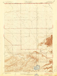
1937 Map of Fairmont
USGS Topo · Published 1937About this map
Fairmont sits at a critical junction of infrastructure and high-desert geography where the foothills of the Angeles National Forest meet the wide expanse of the Antelope Valley. This 1930s era landscape is defined by the engineering of the Los Angeles Aqueduct, which winds through the southern canyons toward the Fairmont Reservoir. The map illustrates a rigid grid of planned desert transit, with numeric routes like 190th Street and Avenue D (also known as Neenach Road) cutting across the alluvial fans. Prominent geological features like Fairmont Butte and the Antelope Buttes rise sharply from the valley floor, serving as natural landmarks for early travelers and settlers. Multiple named drainages, including Kings Canyon, Broad Canyon, and Myrick Canyon, descend from the forest boundary, tracing the natural flow of water toward the settlement at Fairmont.
Find a feature on this map
29 named features on this map. Tap any name to fly to it.
Don’t see what you’re looking for? This feature index may not catch every label — zoom into the map to look around manually.
Map Details
Editions of this 1937 Fairmont Map
4 editions found
Other maps of this area

1903 · Tejon
USGS Topo · 1:125,000

1915 · Elizabeth Lake
USGS Topo · 1:125,000

1917 · Elizabeth Lake
USGS Topo · 1:125,000

1931 · Warm Spring
USGS Topo · 1:24,000

1931 · Little Buttes
USGS Topo · 1:24,000

1932 · Lake
USGS Topo · 1:24,000

1932 · Hughes Lake
USGS Topo · 1:24,000

1932 · Fairmont
USGS Topo · 1:24,000

1933 · Manzana
USGS Topo · 1:24,000

1934 · Little Buttes
USGS Topo · 1:24,000