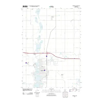
2010 Map of Fairmont
USGS Topo · Published 2010About this map
Fairmont and its string of glacial lakes dominate this Martin County landscape, where the city center is bounded by George Lake, Budd Lake, and Hall Lake. The 2010 geography reveals a structured urban core surrounded by agricultural expanses, with the Fairmont Municipal Airport and Martin County Fairgrounds serving as significant civic hubs. To the north, the smaller settlement of Northrop sits among a network of rural roads and drainage features like Judicial Ditch Number Three. Genealogists will find a high density of burial sites across the quadrangle, including Lakeside Cemetery near the lakefront and several rural plots such as Barvel Cemetery and Immanuel Cemetery. The map also captures the local recreation and cultural history at the Fairmont Raceway and the historic-themed Heritage Acres site, illustrating how the community has integrated its industrial and agricultural identity with its unique lakeside geography.
Find a feature on this map
56 named features on this map. Tap any name to fly to it.
Don’t see what you’re looking for? This feature index may not catch every label — zoom into the map to look around manually.
Map Details
Editions of this 2010 Fairmont Map
This is the sole edition of this map. No revisions or reprints were ever made.
Other maps of this area

1954 · Fairmont
USGS Topo · 1:250,000

1958 · Fairmont
USGS Topo · 1:250,000

1967 · Truman
USGS Topo · 1:24,000

1967 · East Chain
USGS Topo · 1:24,000

1967 · Wilmert Lake
USGS Topo · 1:24,000

1967 · Truman SE
USGS Topo · 1:24,000

1967 · Granada
USGS Topo · 1:24,000

1967 · Fairmont
USGS Topo · 1:24,000

1970 · St James SE
USGS Topo · 1:24,000

1970 · Welcome
USGS Topo · 1:24,000